Introduction
The third field season of the Egyptian-Russian Gebel el-Nour Archaeological Project (GAP) took place from November 8 to December 25, 20251. The work program for the season was based on the results of previous surveys and excavations that took place in 2022 and 2024. The general aims of the Gebel el-Nour Archaeological Project are as follows: 1. To establish the relative stratigraphy and absolute chronology of the archaeological zone in the mouth of Wadi Ghayada; 2. To reconstruct and study the plan of the archaeological zone in the mouth of Wadi Ghayada in its diachronic development; 3. To investigate the remains and functions of ancient infrastructure in the mouth and along Wadi Ghayada; 4. To study the local cultural and natural landscapes of the Wadi Ghayada region; 5. To study the history, economy, and culture of local ancient and medieval populations of the Wadi Ghayada region. 6. To situate the cultural landscape of Wadi Ghayada and its patterns of development within the broader historical framework of the Beni Suef region; 7. To conserve and restore ancient monuments of the archaeological zone in the mouth of Wadi Ghayada.
Archaeological monuments in the mouth of Wadi Ghayada, located on the east bank of the Nile approximately 25 km south of Beni Suef, were first recorded in the archaeological atlas of George Daressy whose work remained unpublished until 2002 [Daressy, 2019, p. 51]. In published records, ancient monuments in the mouth of Wadi Ghayada were briefly described in 1961 and 1991 following German and Egyptian–German surveys conducted in 1958 and 1981 [Kaiser, 1961, S. 41; Gomaà, Müller-Wollermann, Schenkel, 1991, S. 183–184]. The biggest and best-preserved ancient site within the archaeological zone in the mouth of Wadi Ghayada is Gebel el-Nour. Today, it is known primarily for a largely dismantled Greco-Roman limestone temple, at least partially decorated during the reign of Ptolemy II Philadelphus (ruled from 284 to 246 BC). Between 2014 and 2016, Egyptian archaeological teams investigated the central part of the temple area of Gebel el-Nour [Boraik, Eissa, 2014; Boraik, 2015; Eissa et al., 2016; Eissa, Safina, 2019]. These works revealed the remains of a provincial sanctuary (measuring approximately 16.5 × 23.4 m), surrounded by Roman and Byzantine-period structures.
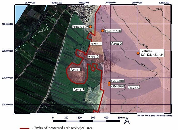
The surveys carried out by the Egyptian–Russian Gebel el-Nour Archaeological Project in 2022 and 2024 [Lebedev, 2023; 2025; Malykh, 2023; 2025; Vetokhov, 2023; 2025] identified six functional areas within the ancient cultural landscape of Gebel el-Nour: the temple area on Kom I (Area I); Kom II, with the remains of presumed monumental structures (Area II); a settlement area around and between Kom I and Kom II, now buried beneath modern agricultural fields (Area III); a settlement area north of Kom II (Area IV); the northern rock-cut cemetery and associated quarry zone (Area V); and the southern cemetery located in wadi deposits (Area VI). In 2024, the project initiated test excavations in the temple area (Area I) and the necropolis (Areas V and VI). In 2025, work continued in Areas I and III–VI at Gebel el-Nour and was extended to the southern part of the mouth of Wadi Ghayada and along the main course of the wadi (fig. 1).
The project employs both traditional and advanced contemporary methodologies, including photogrammetry, 3D modeling, ground-penetrating radar (GPR) survey, and satellite image analysis. It is multidisciplinary in nature and integrates data from a variety of branches of archaeological research, including bioarchaeology, landscape archaeology, settlement archaeology, funerary archaeology, digital epigraphy, etc. To ensure a robust foundation for interpretation, archaeological excavations follow the single-context recording system. Each context is assigned a unique number, classified by type (D for deposits, W for walls and doorposts, C for cuts, and F for other features) and excavated individually. The diverse datasets generated by the project are integrated into an interactive Geographic Information System (GIS).
Aims of the third season of the GAP
During its third season, the mission focused its efforts on excavations in the western part of the Greco-Roman temple complex (Area I) and test excavations in the southern cemetery (Area VI). At the same time, members of the mission continued topographic, archaeological, and geophysical surveys, carried out consolidation works within the Greco-Roman temple zone, and continued the routine study of material culture and bioarchaeological remains.
The main objectives of the season 2025 were as follows: Continuation of archaeological, topographic, and ground-penetrating radar (GPR) surveys in the Gebel el-Nour area; Archaeological survey of the Wadi Ghayada area; Continuation of excavations in the temple zone (Area I) in order to reveal the limits of the pavement in front of the Greco-Roman temple; Continuation of excavations in Area VI in order to complete work in tomb GN 6010 and verify the results of previous GPR surveys; Cleaning, consolidation, and restoration works within the Greco-Roman temple complex; Study of finds from Gebel el-Nour housed in the Ihnasia el-Medina storehouse; Documentation of bioarchaeological data and material culture recovered by the mission.
Surveys in the area of Gebel el-Nour
Survey activities in the vicinity of Gebel el-Nour covered the entire archaeological zone, including the settlement (Areas I–IV), the quarries (Area V), and the necropolis (Areas V–VI). These activities included the recording of surface finds (pottery, faience, glass, and lithics), the removal of modern debris from visible anthropogenic features, subsurface testing with a geological probe, and ground-penetrating radar (GPR) survey.
The recording of surface finds was undertaken in order to determine the extent of the settlement associated with the Greco-Roman temple (Area II). Since every season archaeologists of the mission have access only to passages between plots of land and fields without cultivated vegetation (i.e. after collecting crops, during plowing and immediately after sowing), the mapping of surface material culture is an ongoing activity. It was observed that pottery, predominantly dating to the Roman and Byzantine periods, is abundant on the surface of modern agricultural fields to the north and northeast of the temple area (Area I), whereas it is very scarce to the east, south, and west. Preliminary results of surface survey suggest that the Roman and Late Antique settlement developed primarily to the north and northeast of the temple, in the direction of the modern village of Gebel el-Nour, placing the temple area at the southern margin of the settlement.
However, it should be borne in mind that the distribution of surface finds in Egypt may correlate only weakly with the actual extent of settlement areas. Surface material alone cannot be considered an indicator for ancient activity. The location and even the survival of surface materials may have been affected by the extraction of occupational deposits and their subsequent use as fertilizer (sebakh) on surrounding agricultural fields [Bailey, 1999]. The very fact that potsherds almost disappear from the surface of the fields located to the west of the channel dug sometime before early 20th century some 130 m west of the temenos wall might indicate that at least some pottery recorded in the farmlands between the temple zone (Area I) and the channel may have been brought with sebakh. It should also be noted that the virtual absence of Ptolemaic pottery on the surface renders both the extent and the location of the Ptolemaic settlement associated with the temple of Gebel el-Nour rather uncertain. As in the temple area, Ptolemaic occupation deposits within the settlement zone may lie below the current groundwater level.
Cleaning of visible anthropogenic features from modern debris was carried out in the quarry zone and the northern rock-cut cemetery (Area V). In addition to removing modern refuse as part of the mission’s ongoing site-management efforts, this work aimed to verify the nature of the artificial cuts first recorded during the 2024 season and to incorporate them into the general map of the area. These activities resulted in the identification of a number of potential rock-cut tombs, as well as extensive evidence of stone extraction. The cleaning operations were combined with subsurface testing using a geological probe, which helped distinguish between deep cuttings (potential tombs) and shallow cuts, presumably associated with limestone quarrying.
Altogether, 59 different artificial features (tombs, cuts, burial recesses) or clusters of features (mostly areas of stone extraction) were recorded over 9 ha of the northern cemetery and the quarries. Among the most interesting objects are rock-cut tombs with partly collapsed entrances. One of these tombs (feature 568) still houses at least one anthropoid limestone sarcophagus or sarcophagus lid oriented with the head to the south-west. Today, this tomb is almost completely covered with debris and may be one of the rock-cut structures observed by F. Gomaà, R. Müller-Wollermann, and W. Schenkel in April 1981: “The local necropolis lies directly northeast of the settlement ruins and contains rock-cut tombs, some of which remain unexcavated, while others have been looted. Of particular note is a tomb with several burial chambers branching from the central chamber on both sides and at the rear. Three anthropoid stone sarcophagi lie at its entrance” [Gomaà, Müller-Wollermann, Schenkel, 1991, S. 184].
In addition to the rock-cut hypogea, one of which was excavated in 2024 [Lebedev, 2025, p. 15–16], a previously unrecorded in this archaeological zone type of burial installation, namely anthropoid burial recesses, was identified. Three complete recesses (features 421, 423, and 424) and one apparently unfinished example (feature 420) were recorded on a limestone slope in the far eastern part of the Northern Cemetery, approximately 280 m east of the settlement. This peripheral area of the cemetery also preserved evidence of stone extraction and, probably, additional rock-cut tombs.
The complete burial recesses range from 1.9 to 2.0 m in length and from 0.57 to 0.66 m in width. The orientation of the original interments varied slightly but followed a consistent pattern, with the heads placed toward the northwest. This orientation corresponds to the alignment of local limestone outcrops, which appears to have influenced the layout of many anthropogenic features in the northern part of the mouth of Wadi Ghayada. At the same time, it broadly corresponds to the position of the setting sun during the summer months, particularly from early June to early August, in this part of the Nile Valley2.
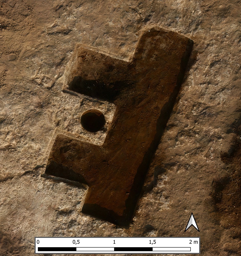
Among the other features recorded during the survey, particular attention may be drawn to a number of rock-cut installations presumably associated with production activities. The most intriguing of these is Feature 609, recorded at the northern edge of the Northern Cemetery (fig. 1-2). Its location was indicated by local workmen employed by the mission. Following surface cleaning, a rock-cut recess or corridor measuring 2.67 m in length and 0.70 m in width, oriented along a northeast–southwest axis, was exposed. Two additional niches, measuring 0.60 × 0.55 m and 0.70 × 0.57 m respectively, adjoin the corridor on its western side. Both niches preserve narrow rock-cut ledges that may have supported some form of covering, possibly limestone slabs. Between the niches is a circular depression of unknown depth measuring 0.31 m in diameter.
Tests with a geological probe revealed that the floor of the corridor slopes from northeast to southwest for approximately 0.5 m. The mission's workmen reported that there was a staircase or sloping passage that led to a series of underground chambers, which they claimed to have explored as children. Before excavations, however, this information cannot be verified and should be treated with caution. Based on the currently available evidence, the feature may represent the remains of a Roman or Byzantine press installation rather than a funerary structure.
GPR surveys were conducted in Areas I, V, and VI. In Area I, the survey focused on the territory southwest of the temple with the aim of identifying possible stone structures located within the outer enclosure wall of the sacred complex. Only one anomaly potentially associated with a structure was recorded to the south of the temple vestibule (fig. 3). The lack of other clear anomalies may be explained by the presence of groundwater, salt accumulation in the soil or the large number of displaced stone blocks within the occupation deposits.
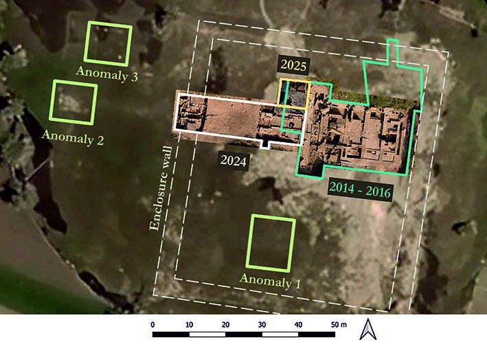
By contrast, GPR investigations conducted west of the enclosure wall confirmed two large anomalies: one (at least 5 by 9 m) located on the main axis of the temple approximately 30 m west of the enclosure wall, possibly representing an embarkation facility or some other element of temple infrastructure, and another (about 7.5 by 7.5 m) situated approximately 15 m north of the dromos, outside the temenos. The possible presence of stone or mudbrick structures beneath the surface in these two areas is further supported by the relatively sparse and weak vegetation visible on some satellite images (fig. 3).
In the northern cemetery and quarry zone (Area V), the GPR survey was limited to a series of test scans along limestone outcrops. These scans did not reveal any large voids; subsequent testing with a geological probe confirmed that the surveyed area functioned primarily as a quarrying zone, with little evidence for substantial subterranean installations.
Significantly greater effort was devoted to the continuation of the GPR survey in the southern cemetery (Area VI). In 2025, the geophysical team surveyed 8,750 m² in this part of the Gebel el-Nour necropolis, substantially expanding upon the 6,500 m² surveyed in 2024 (fig. 4). In four 25 × 50 m squares (Squares 1–2 and 4–5) and one 50 × 50 m square (Square 3), the new survey identified 26 anomalies preliminarily interpreted as potential ancient structures that require further detailed analysis and test excavations. The test GPR survey of the southernmost Square 6 revealed no major anomalies comparable to those detected to north. Based on surface finds and information provided by MoTA inspectors and local residents, Square 6 may be occupied by simple shallow graves and burials in wooden coffins; however, the full extent of this minor cemetery remains unknown. In general, the GPR results confirmed the eastern and southern limits of the southern cemetery occupied by potential subterranean structures (possibly tombs), as initially proposed in 2024 on the basis of data from the first topographic survey.
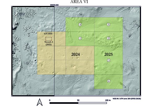
The topographic survey conducted in 2025 focused on the southern part of the northern cemetery (Area V). The area was documented using a GoPro 11 camera mounted on an eight-metre pole. The resulting 3D model and digital elevation model (DEM) were generated from over 5,000 photographs. The new model complements the areas of the necropolis documented using the same technique in 2024 and made it possible to produce a complete topographic plan of the burial ground of Gebel el-Nour.
Archaeological survey in the Wadi Ghayada area
As part of the study of the regional cultural and natural landscapes, the mission initiated a survey of the Wadi Ghayada area. In particular, team members examined the archaeological zone in the southern part of the mouth of Wadi Ghayada and confirmed the presence of a small number of scattered Greco-Roman shards south of the modern village of Ghayada el-Sharkiya. These finds are likely associated with a settlement and a cemetery that once may have existed in this area but now presumably buried under the modern village and its extensive cemetery. Even the scarce remains of ancient cultural landscape reported by earlier surveyors [Kaiser, 1961, S. 41; Gomaà, Müller-Wollermann, Schenkel, 1991, S. 183–184] and recorded on some 20<sup>th</sup> century maps [Daressy, 2019, p. 51] have not been observed. Ruins of an ancient tower marked on some early 20<sup>th</sup> century maps over the limestone plateau to the south of Ezbet Abu el-Nour3 are either destroyed or under the modern-day cemetery or the powerplant. According to the local inspectorate of Beni Suef, an Egyptian mission of the Supreme Council of Antiquities under the supervision of Amal Farag excavated in 1997 to the north of Ezbet Abu el-Nour and west of Ghayada el-Sharkiya a rock-cut underground structure consisting of a staircase leading to a chamber at its bottom (coordinates: 305914, 32019594). Today, this previously excavated structure (possibly a well or a nilometer) lies beneath a modern village road (fig. 5).
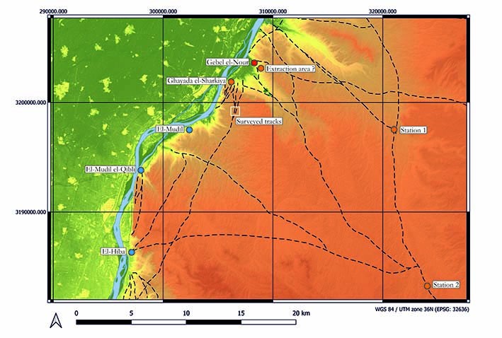
Additionally, the team documented animal tracks associated with traditional caravan routes. Most of the tracks traced in 2025 using CORONA satellite images [Lebedev, 2025] are now very disturbed or destroyed by contemporary infrastructure. Only two tracks about 550 m long crossing the limestone plateau south of the mouth of Wadi Ghayada were confirmed on the ground and described (fig. 5). East of the modern asphalt road connecting Beni Suef and Minia, a potential ancient extraction site covering approximately 1.7 ha was recorded (coordinates: 309338; 3203668) (fig. 5). It was probably used for the extraction of chert cobbles from the upper strata of the Eocene plateau, as evidenced by comparable sites elsewhere in Middle Egypt (for example, in Wadi el-Sheikh, located approximately 25 km south of Gebel el-Nour). Test excavations are required to confirm the nature and date of the activity that took place in this area.
Using satellite imagery and in cooperation with the Beni Suef Inspectorate, the mission identified and conducted a preliminary documentation of two caravan stations. One station (56 × 47 m) is located immediately north of Wadi Ghayada (coordinates: 321049; 3197520), while the second (49 × 45 m) lies in the area where Wadi Ghayada branches off from the larger Wadi Sannur (coordinates: 324076; 3183242). Both stations appear to have been constructed around water sources and are situated along the “Alabaster route” (Darb el-Rukham) leading from the mouths of Wadi Ghayada and Wadi Sannur to the alabaster (travertine) quarries in Wadi Muathil, approximately 45 km southeast of Gebel el-Nour. The first station is located at a distance of 15 km from the mouths of Wadi Ghayada and Wadi Sannur, the second was another 15 km upstream the wadi system. Both stations were constructed out of local limestone and demonstrate similar drystone building techniques. Around the second station located deeper in the desert, and especially on the surface of the dumping area to the south of it, some pottery was observed. Datable shards confirm that this site was likely in use as a stopping point from at least Late Antiquity (Byzantine Period) through the Ottoman Period. The surveyed stations may have been constructed under Mohamed Ali Pasha who commanded a large-scale extraction of alabaster (travertine) from Wadi Muathil for his mausoleum in Cairo [Harrell, 2024, p. 524–526]. This preliminary interpretation and dating should be tested by further works in and around these structures.
Continuation of excavations in Area I
In 2025, the mission continued excavations west of the Greco-Roman temple decorated during the reign of Ptolemy II. Excavations covered an area of 52 m² in squares 172–173 and 178–188 of the local grid established for the temple area in 2022. The new trench (Trench 3) adjoined from the north Trench 1 excavated in 2024 (fig. 6). The aim of this work was to complete excavations initiated in this area by the Egyptian team in 2015–2016 [Eissa et al., 2016]. Earlier investigations had documented upper stratigraphic layers and revealed remains of Late Roman and Byzantine Period walls and pavements constructed of fired bricks, mudbricks, and reused limestone blocks. The GAP focused on the study of Late Roman and Byzantine Period occupation deposits and architectural remains, as well as on defining the extent of the stone pavement (101F) identified west of the temple in 2015–2016 and again studied in 2024.
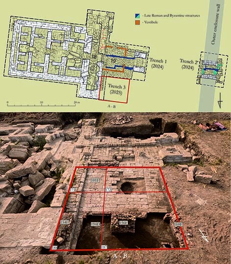
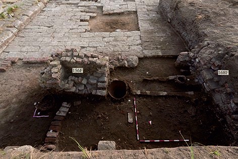
All Late Roman and Byzantine Period structures recorded in Trench 3, regardless of their construction phases, are associated with three brick platforms. The first platform (context 154F; 160 × 88 cm) is attached to the temple pronaos (Room 18). The second platform (context 156F; 160 × 106 cm) was constructed approximately 2.5 m west of the first one. The third platform (context 168F) lies further 2.5 m west of the second one; its full dimensions remain unknown since only the eastern face of this feature has been exposed. Low walls constructed of fired bricks and reused limestone blocks extended northward from the second and third platforms, forming a room approximately 2.5 m in length. These walls rested on earlier occupation deposits associated with a cooking installation (fig. 7).
In all contexts investigated in Trench 3, with the exception of deposit 194D, ceramic material dating to the Late Roman and Byzantine periods (4th–7th centuries AD) was recorded. The assemblage was dominated by fragments of Middle Egyptian wine amphorae of the Late Roman 7 (LR 7) type; other vessels included Asia Minor/Cypriot amphorae of the LR 1 type, Palestinian amphorae of the LR 4 type, and Aswan amphorae. The assemblage also contained kitchen ware and tableware. Kitchen ware is represented by fragments of cauldrons, storage jars, braziers, large vats, and lids. Some cauldrons and storage jars have been originally decorated with coarse painted geometric motifs executed in a yellowish-white pigment on red or red-brown surfaces. Tableware comprises various types of bowls, plates, and jugs (sometimes equipped with a filter in the neck); the latter are often decorated with black, red, and brown painting on a white slip. A significant proportion of the tableware was made of kaolinitic clay of beige-pink or beige-orange hues and was likely imported from Aswan. Local pottery is generally of lower quality and frequently exhibits uneven firing, which was likely characteristic of workshops located in the immediate vicinity of Gebel el-Nour.
Of particular interest is the discovery in Square 187 of the upper part of a ceramic “frog” lamp (GN25/I-187/1) decorated with a relief depiction of hands. It was found on an assumed ancient walking surface at the interface between deposits (layers) 153L and 159L. Such lamps are typically dated to the 2nd–4th centuries AD. In the same square, from context 179L, the lower part of another lamp (GN25/I-187/2), bearing a stamp and typologically characteristic of Byzantine Period, was recorded.
In Squares 187 and 188 (context 191L), a complex interpreted on the base of associated pottery as a kitchen was excavated (fig. 7). Within it, a large thick-walled vat, a storage jar, a brazier, a cauldron, and the upper part of a Palestinian amphora of the LR 4 type were found in situ. The amphora had been set rim-down into the ground and was likely used as a container for charcoal, as indicated by the heavy soot layer on its interior. In the northern part of the room, a broken red-slipped plate (GN25/I-188/2) dating to the Byzantine Period was recorded.
In context 194L, alongside the usual varieties of Byzantine pottery, a rim fragment of a thin-walled bowl (GN25/I-188/1) decorated in the barbotine technique and dated to the 2nd century AD was found. This find likely marks the beginning of earlier Roman Period deposits. The same stratum also yielded a small bronze statuette of a male deity (GN25/I-187/m4), most probably Thoth.
A bronze coin (GN25/I-156/m1), dating to the beginning of the reign of Diocletian5, was found directly beneath wall 160W. Since this wall was constructed of reused stone, including blocks extracted from the temple foundations, the find contributes to the chronology of the temple’s reuse as a quarry. It appears that by the reign of Diocletian, or shortly thereafter, the temple of Isis had already been substantially dismantled, and the area in front of its pronaos had been replanned to accommodate new structures.
Continuation of excavations in Area VI
In 2025, investigations were continued in burial chambers GN 6012 and GN 6013 of tomb GN 6010 discovered in 2024 [Lebedev, 2025]. In addition, a new trench (Trench 3) was set to the south of tomb GN 6010 in order to verify the results of the GPR survey conducted in 2024. In the course of this trial investigation, a previously unknown tomb, designated GN 6020, was discovered.
GN 6012
Chamber GN 6012 measures 2.2 × 4.14 m; its floor was recorded at a depth of 4.8 m below the modern ground surface (27.84 m.a.s.l.). Groundwater that actively penetrated the chamber from the wadi aquifer significantly complicated excavation and documentation processes as well as affected the preservation of skeletons and burial equipment.
The main volume of the chamber was filled with deposits of sand and clay with small desert pebbles, representing the remains of the collapsed ceiling. In the 2025 season, three ceramic coffins (nos. 4, 5, and 6) and two skeletons (Burials 8 and 16) were excavated in addition to two ceramic coffins uncovered in GN 6012 in 2024 (fig. 8).
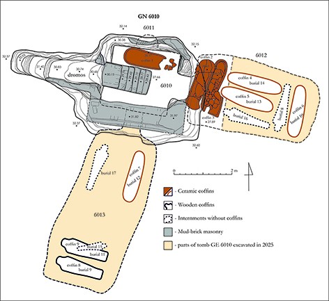
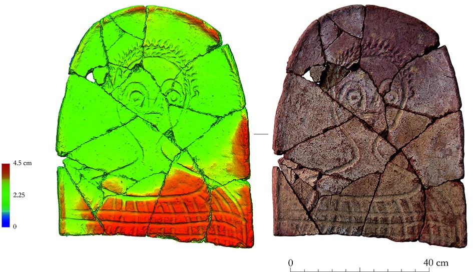
Coffin 4 (1.95 × 0.54 × 0.40 m) was placed along the northern wall of the chamber. Within its fill, a broken lid made of three separately produced pieces was found. The piece that originally covered the upper part of the body (GN25/6012/p1) was decorated with a bust-length depiction of a person wearing a tunic (fig. 9). The representation was modeled with fingers in the unfired clay. Inside the coffin, a poorly preserved adult skeleton was found (Burial 14), lying supine with the head oriented to the west. To the north of the western end of the coffin, two small glass unguentaria (GN25/6012/g1 and GN25/6012/g2) crushed by the collapse of the ceiling were found.
Coffin 5 (1.9 × 0.59 × 0.40 m) was located immediately south of Coffin 4 and parallel to it. Two poorly preserved skeletons were found inside (Burial 13). Both individuals were oriented with their heads to the west. Between the skulls, fragments of a small glass unguentarium were recorded (GN25/6012/g2). The vessel had been crushed in antiquity as a result of the collapse of the chamber ceiling.
Coffin 6 (1.85 × 0.55 × 0.38 m) was situated along the eastern wall of the chamber. Above the coffin, a fragment of a limestone offering table (GN25/6012/st1) was recorded. Another fragment of the same offering table (GN24/6010/st3) had been discovered during the excavation of robber debris inside GN 6010 in 2024. At the bottom of the coffin, a poorly preserved skeleton of an adult (Burial 10) was uncovered. The individual was oriented with the head to the north.
Beneath the coffins, a layer containing charcoal fragments, small mummy fragments, rodent bones, and small human bones was recorded. Beneath Coffin 6, compactly arranged fragments of a small glass cup (GN25/6012/g4) were uncovered.
Burial 8 was situated between Coffin 6 and Coffins 4 and 5. The poorly preserved and disturbed skeleton lay extended, parallel to Coffin 6, with the head oriented to the south.
Burial 16 was recorded between Coffin 5 and the southern wall of the chamber. The poorly preserved skeleton was oriented with the head to the west, with a slight deviation toward the north. Fragments of a crushed plaster mask were found to the north of the skull.
GN 6013
Chamber GN 6013 measures 2.50 × 5.50 m and was cut along a north-northeast-south-southwest axis. In plan, it is almost rectangular and has rounded corners (fig. 8). The ceiling collapsed in antiquity, making it impossible to determine the original height of the chamber.
The chamber floor was recorded at a depth of 4.7 m below the modern ground surface (28.36 m.a.s.l.). The northeastern wall was constructed of mudbrick and contained a passage 0.65 m wide leading to the central room of the tomb (GN 6010).
The main volume of the chamber was filled with layers of windblown sand and loam with small pebbles that resulted from the collapsed virgin soil. The room had been looted in antiquity and was subsequently entered again in the 21st century: a robber’s shaft was recorded in the upper part of the chamber close to its southwestern end.
Within the chamber, one ceramic coffin (no. 7), two wooden coffins (no. 8 and 9) and four internments (Burials 9, 11, 15, and 17) were excavated. Along the southern wall of the chamber, there was a large deposit of disarticulated bones and skulls from mummified individuals that had been replaced and discarded. Judging from the skulls, number of skeletons dumped in this part of the chamber may have exceeded 25.
Coffin 7 (1.92 × 0.40/0.53 × 0.30 m) was located along the eastern wall of the chamber, in its northern part. The coffin was covered by a ceramic lid composed of three parts, originally belonging to two different lids. On the northern part of the lid, a small round-bottomed ceramic bowl was found placed upside down. Inside the coffin, a poorly preserved adult skeleton was uncovered, lying supine with the head oriented to the north (Burial 12). The bones were partially displaced, indicating that the burial had been looted.
Burial 9 was uncovered along the southern wall of the chamber and consisted of the remains of an adult individual whose body had been embalmed and buried in a wooden coffin (Coffin 8). The skeleton lay supine, extended with the head oriented to the west, with the forearms crossed on the chest. Minor remains of a wooden anthropoid coffin (preserved length 1.78 m) were recovered, bearing faint traces of polychrome decoration (red, white, green (?), blue, yellow, and black). The coffin rested on two limestone blocks (0.41 × 0.29 × 0.145 m and 0.41 × 0.38 × 0.145 m) with smoothed surfaces (fig. 10).
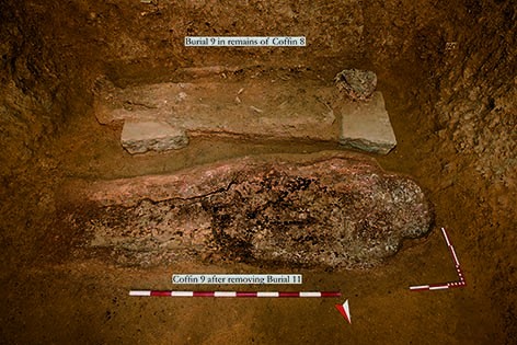
Burial 11 was located parallel to Burial 9, 10–15 cm to the north. It consisted of the remains of an adult individual whose body had been embalmed and buried in a wooden coffin (Coffin 9). The skeleton lay supine, extended with the head oriented to the west, with the arms crossed on the chest. During excavation, a small round faience (?) bead was recovered beneath the skeleton.
Coffin 9 (length 2.1 m) rested directly on the soil and its wood completely decayed. Traces of pigments (red, white, green, blue, yellow, and black) applied over a thin plaster layer suggest that the coffin was once brightly painted.
Burial 15 consisted of a redeposited skeleton of a child, extended with the head oriented to the east; the skeleton measured 1.0–1.1 m in length and preserved some traces of embalming. The mummy had been placed on top of the coffin associated with Burial 11. Some bones were not in anatomical order: the bones of the right arm were displaced to the north, and vertebrae from the thoracic and pelvic regions were redeposited. Bronze wire anklets (GN25/6013/m1 and GN25/6013/m2) were found on both ankles.
Badly disturbed Burial 17 was recorded in the northeastern part of the chamber, along its northeastern wall. This burial consisted of a partially preserved inhumation with the head oriented to the north-east. Preserved elements included a part of the ribcage with the thoracic spine and the arm bones. The remains exhibited clear traces of embalming. The floor of the chamber between Coffin 7 and Burial 17 was littered with small fragments of textile presumably from mummy bandages. These traces might indicate the presence of one more internment that was later displaced or destroyed (one may recollect the lower part of a mummified body recorded in 2024 on the mudbrick staircase in room GN 6010). In addition, some separate bones were found scattered over the floor of the chamber.
Within burial chamber GN 6013, fragments of Middle Egyptian wine amphorae of the AE 3 type, as well as bowls and cauldrons dating to the Roman period, were recovered. In addition, a fragment of a “frog” lamp (GN25/6013/1) decorated with hands was found; another fragment of the same lamp (GN24/6012.1/1) had been recovered during the 2024 season in robbers debris that filled the upper part of the adjacent burial chamber GN 6012. A complete “frog” lamp (GN25/6013/2) with faintly impressed decoration was also recovered. On the lid of the ceramic coffin, a small round-bottomed bowl (GN25/6013/3) was found. In the southern part of the chamber, near the skeletons, a complete miniature cauldron (GN25/6013/4) with two pseudo-handles was recovered. All of the pottery mentioned above is typical of the Roman period.
GN 6020
During the 2024 season, several dozen anomalies were detected by the GPR survey in the Southern Cemetery (Area VI). As was stated above, to verify these results, Trench 3 was laid out over one of the anomalies recorded south of tomb GN 6010 (fig. 4). Excavation revealed a subterranean structure interpreted as a hypogeum tomb labeled GN 6020.
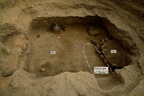
In its upper part, the main fill of GN 6020 consisted of sand containing several compact lenses of sand. These lenses subsided toward the center of the structure and were likely formed during periods of water accumulation. In the central part of GN 6020, the sand layers were cut by a pit containing Burial 7 (fig. 11). It was oriented along the west-northwest–east-southeast axis and had been partially disturbed by a looters’ pit (83C). At the bottom of the grave, the skeleton of an adult individual was uncovered in a semi-seated position. The head was raised above the chest and oriented east-southeast. The arms were slightly flexed at the elbows and extended along the body; the right hand rested on the right side of the pelvis, while the left hand lay near the left pelvic bone. To all appearances, that was an intrusive Muslim burial.
Within the fill of the looters’ pit in the central part of the chamber, several well-preserved ceramic vessels were recovered, including a lekythos (GN25/6020/1), two jugs with loop handles (GN25/6020/2 and GN25/6020/4), and a small unguentarium (GN25/6020/3) preliminary dated to the Ptolemaic period. On this basis, a somewhat earlier date may be proposed for tomb GN 6020 in comparison with the hypogeum tomb GN 6010.
Beginning at an elevation of 30.28 m a.s.l., another circular pit (Context 70C; diameter 0.9 m) was recorded in the southeastern part of the structure (fig. 11). Its fill contained bones of various animals, the overwhelming majority consisting of dog skeletons, many of which preserved in anatomical articulation.
The central room of tomb GN 6020 measures 2.35 × 1.9 m and is oriented along a south-southwest to north-northeast axis. Along the southern wall of the room, a structure constructed of mudbrick was recorded; the bricks rested directly on sand deposits. The function of this structure will be investigated in future seasons.
In the northern wall of the main room, a passage leading to burial chamber GN 6021 was identified. In its lower part, remains of a mudbrick blocking were preserved. Another burial chamber was likely cut into the western wall of the main room. Further excavations in tomb GN 6020 are planned for 2027.
Consolidation and restoration work inside the temple area
In 2025, the mission continued both emergency and protective conservation work. Emergency interventions were carried out at the main gate of the outer enclosure wall of the temple area and at the gate in front of the temple. The remaining walls of the vestibule in front of the temple were also consolidated. Protective work continued inside the temple, particularly in Rooms 5 and 18. In Room 18, the remaining pavement—previously affected by an unstable foundation and vegetation growth—was completely rebuilt on a new solid base incorporating a drainage interlayer and geotextile layers designed to prevent the regrowth of halfa grass that is a crucial factor of bioerosion.
Conclusion
The 2025 season marked a significant expansion in both the scope and methodology of the Gebel el-Nour Archaeological Project. It considerably advanced our understanding of the archaeological zone at the mouth of Wadi Ghayada and inaugurated a regional survey that began to shed light on the broader cultural context and resource base of the ancient and Byzantine settlement in the vicinity of the modern village of Gebel el-Nour. The new investigations confirmed the complex nature and long history of the main site while also revealing further challenges and research questions for the mission.
Excavations in the temple area made it possible to date the decline of the Greco-Roman sanctuary to the third century AD and contributed significantly to our understanding of the activities that took place in front of the temple during the Byzantine period. The surface survey around the temple provided new data for estimating the extent of the ancient settlement zone.
The multidisciplinary survey of the necropolis identified almost sixty previously unrecorded rock-cut features, either visible on the surface or detected using a geological probe, as well as more than twenty geophysical anomalies. One such anomaly, detected in 2024, was tested through excavation and proved to be a hypogeum (GN 6020). Further study of the landscape, the typology of burial installations, and the associated material culture confirmed that the Gebel el-Nour necropolis underwent a complex process of diachronic development.
Tomb GN 6010, the excavation of which was completed in 2025, appears to be the first Greco-Roman hypogeum to have been systematically investigated on the east bank of the Nile in Beni Suef Governorate in the twenty-first century. Its architecture, burial practices, and distinctive material culture—including decorated ceramic coffins, plaster masks, and pottery—provide unique comparative data for the much more extensively investigated archaeological record of the densely occupied west bank of the Nile.
At the same time, the conservation and restoration work undertaken by the mission in 2025 contributed to the preservation of the temple area of Gebel el-Nour.
Примечания
- Members of the mission: Lebedev Maksim (Director of the mission), Mohamed Ibrahim Mohamed (General manager of Beni Suef area, head of the Egyptian part of the team), Malykh Svetlana (Field director of the mission, ceramologist), Vetokhov Sergey (architect), Malykh Sergey (archaeologist), Ghada Moawad Yassin (archaeologist), Alexey Sergeev (archaeobotanist), Maksim Menshikov (archaeologist), Mikhail Iakomulskii (archaeologist), Yana Malysheva (photographer), Natalia Safonofa (specialist in 3D, art historian), Pavel Vorovskii (geophysicist), and Fedor Morozov (geophysicist). Restoration team: Osman Ahmed Mohamed, Ahmed Gamal Emam, and Mohamed Adel Abdullah (Supreme Council of Antiquities). Inspectors of the mission: Eman Eissa Mohamed Youssef (November 8 – December 8, 2025) and Shaima Abdallah (December 8–25, 2025). Institutional funding: Institute of Oriental Studies of the Russian Academy of Sciences and Institute of Archaeology of the Russian Academy of Sciences. Private funding: sincere gratitude to philanthrope Iliya Evgenevich Perekopsky who financially supported the work of the mission. Technical support: the mission is grateful to the Egyptian-Russian Foundation for Culture and Science and its President Shady Hussein El-Shafei for the GPR equipment provided during the field season. ↩
- According to the web-source www.sunculc.org. ↩
- See, for instance: Survey of Egypt. Beni Suef, Sheet 68/60. Scale 1:100,000. First Survey of Egypt Edition, 1926; A.M.S. 1, 1949 and Survey Department, Egypt. Mudira Beni Suef, sheet 111. Scale 1:50,000. Cairo: Survey Department, 1908. ↩
- Unless otherwise stated, all coordinates are reported in the WGS 84 / UTM Zone 36N coordinate reference system. ↩
- Attribution by S.E. Malykh (IOS RAS) and E.Yu. Goncharov (IOS RAS). ↩